"Dirty old river, must you keep rolling, flowing into the night."
Ray Davies wrote those words in 1967 for this river and this specific bend of it, the way you write something for a place that has been getting into you for years without your permission.
The Thames does that.
Brown, tidal, ancient, indifferent to everything built along its banks. It was here before London decided to become London and it will be here after whatever London becomes next. It just keeps rolling. And along the south bank it holds, within less than two miles, the Houses of Parliament and the London Eye and Tate Modern in a former power station, landmarks so familiar they have become almost abstract, postcards the city keeps sending itself. One bank. One river. One of the most spectacular stretches of city on earth.
Waterloo does something to the people who know it. It gets in. Davies felt it from a window above the south bank and couldn't leave it alone, couldn't look away, until eventually he had no choice but to give it back to the river in a song. That pull, that particular gravity, is still here. It lives in the streets behind the landmarks, in the neighbourhood the postcard never shows, in the Waterloo that remains when the crowds thin and the lights dim and the Thames keeps rolling, as it always has, into the night. That is the place this guide is about.
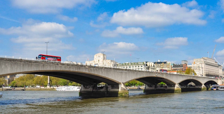
On Waterloo Bridge: a 360° turn
Most places ask you to choose. The grand tour or the quiet street. The famous view or the local pub. The thing you came to see or the thing you stumbled into. Waterloo doesn't ask you to choose because it never separated those things in the first place. Start on the bridge. Stand still, don't rush the photograph. From here, London arranges itself in a wide, generous circle. Some of what you see is instantly recognisable. Some of it only reveals itself when you step down. Turn with the river.
The Thames bends toward the old city
Look east and the Thames curves gently toward the historic core. The dome of St Paul's holds the horizon, steady and pale, while the city spreads beneath it in layers of streets, bridges, and rooftops that catch the light differently as you move. Below you, the South Bank begins its slow stretch toward book markets, open foyers, and the layered concrete terraces of the National Theatre. Walk that direction and the skyline is grand and the ground level is human: undercrofts full of skateboarders, quiet benches facing the water, staircases that lead nowhere obvious until you take them.
Between east and south: the bridge gives way to the bank and the bank gives way to the backstreets. This is where the turn happens without you quite noticing. The river noise fades. The crowd thins. You are no longer walking toward something famous. You are just walking.
Rails, rooftops and quiet streets
Turn south and the view tightens. Railway lines thread out from Waterloo Station across rooftops and brick arches. Less postcard, more pulse. Drop down from the bridge and follow those tracks to Lower Marsh, where the city softens into market stalls and long-running cafés and shopfronts that predate the word vibrant. Tunnels beneath the platforms carry layers of graffiti that will not look the same tomorrow. A few streets further and you are among Georgian terraces where daily life continues, largely indifferent to the river's spectacle. This is the part most visitors miss. It is five minutes from where you are standing.
Between south and west: you pass back through the station's gravity, the pull of departures and arrivals, the particular energy of a place where everyone is either coming or going. Cut through it or skirt around it. Either way, the river reappears ahead of you like a reminder.
Landmarks and riverside cinematic stretches
Turn west and the landmarks line up: the clock tower of the Palace of Westminster anchoring the horizon, the arc of the London Eye lifting slowly above the trees. Walk that way and you pass through Jubilee Gardens and into one of the city's most photographed stretches of river. It is cinematic and it knows it. But even here, between the attractions, there are quiet corners along the embankment where the sound drops and the river feels wider and something of the neighbourhood's older self still comes through.
Between west and north: the city shifts register again. The tourist stretch softens into something more purposeful. People around you are going somewhere rather than looking at something. The streets narrow slightly, the architecture changes, and for a moment Waterloo feels less like a destination and more like a place people actually live.
The West End gathers
Turn north and the West End gathers beyond the Strand, historic façades, hidden courtyards, and theatres tucked behind busy roads. The Old Vic is minutes away. So is Covent Garden. The city compresses here in a way that feels almost unlikely.
Between north and east: you are back at the bridge. The full circle complete. The river below you exactly as you left it, rolling, unhurried, the same water it always was.
From this single spot you can see icons in almost every direction. What you cannot see from up here are the transitions: the staircases off the bridge, the narrow cuts between buildings, the market street under the tracks, the tunnel that turned itself into a gallery without asking anyone's permission. Those are the parts that stay with you. Stand on the bridge and you feel the scale of London. Step off it and, within minutes, you feel the neighbourhood underneath it. The river holds both. It always has.
A name borrowed from a battle: history of Waterloo
Before Waterloo was a neighbourhood, it was a problem
Before Waterloo was a neighbourhood, it was a problem. For centuries, it was Lambeth Marsh, flat boggy ground at the northern edge of Lambeth, flooded regularly by the Thames.
On Elizabethan maps, it appears as open country, not because it was pleasant, but because nothing could be built on it.
Lower Marsh still runs through the heart of the neighbourhood, its name the only admission that the ground beneath market stalls and cafés was once something you could sink into.
A place built on land that was not meant to hold anything became one of the most trafficked patches of earth in Europe, and the tension between instability and density never entirely left.
The river made it worth it
People came for the Thames, not the terrain. Traders, ferrymen, anyone who needed the river to earn a living.
The marsh had been drained, made solid enough to stand on, and that was enough. You did not choose this place because it was pleasant. You chose it because it was there, the river was useful, and the rent was low enough to make the smell tolerable.
Waterloo Bridge opened in 1817, named for the battle two years earlier in which Wellington defeated Napoleon outside Brussels.
In Middle Dutch, Waterloo means water and forest, a neighbourhood named for a battle on land it has never once resembled.
The railway and what it cost
Waterloo Station opened in 1848 on brick arches above ground that still could not be trusted. It was never meant to be a terminus.
The plan was to push the line through to the City, but the City blocked it.
Waterloo got stuck, became the place where trains arrived, platforms duplicated, booking offices multiplied, and music hall comedians wrote jokes about it.
Seven hundred homes were demolished to extend the line, and hundreds of families were displaced.
The station rose elevated, as if preferring not to look at what it had replaced.
The neighbourhood grew despite, or perhaps because of, this chaos.
World War II and what remained
The Second World War arrived in Waterloo without warning. Incendiary bombs set the area around the station alight, fracturing water mains and leaving firefighters powerless.
The Old Vic on the Cut took damage. St John’s Church, built in 1822, was hit and sat wounded for years.
The South Bank, the strip of riverfrontage between County Hall and Waterloo Bridge, was bombed and left in ruins. Twenty-seven acres of industrial ground became wasteland.
The devastation was immense, but it also planted a question about what London could become from this blank slate, and what a neighbourhood could rebuild when the city had changed around it.
The festival on bombed ground
In 1951, Britain built a festival on the South Bank wasteland. The Dome of Discovery was the largest domed structure in the world at the time.
The Skylon, a steel needle floating above the ground. The Royal Festival Hall, with its glass façade open to the river. A broke and bombed country deciding on a patch of South Bank to build the most optimistic architecture it could imagine.
Churchill called it socialist propaganda and ordered it cleared. The Dome and Skylon came down. Only the Royal Festival Hall survived, a single reminder that the festival had happened.
Someone always tried to erase Waterloo, and something always remained.
After the rubble
The festival’s vision took decades to root.
The National Theatre opened in 1976. The book market under Waterloo Bridge appeared in the 1980s.
Skate spaces colonised concrete beneath the arts complex. Streets kept doing what they always had. Lower Marsh kept its market. Roupell Street kept its terraces.
The Old Vic rebuilt.
Waterloo did not become what it is through a plan. It became what it is through accumulation, recovery, culture claimed from wasteland, a neighbourhood that kept its shape while the city changed its mind around it. It is the sum of damage, repair, and persistence.
Exploring the streets of Waterloo
Waterloo is a neighbourhood that unfolds as you walk through it, where the familiar and the unexpected exist side by side. Along the river and through quiet streets, the city reveals its layers: markets buzzing with life, terraces that whisper of Georgian times, galleries tucked beneath railway arches, and theatres that have shaped generations. Every turn offers something new, a landmark to admire, a hidden corner to linger in, or a street that feels untouched by time. The following sections guide you through the places that define the character and pulse of Waterloo, from the iconic to the overlooked, each with its own story to tell.
Where the landmarks gather
London Eye & County Hall
At this bend in the river, the London Eye turns above Jubilee Gardens while County Hall wraps around it with SEA LIFE, Shrek’s Adventure and the London Dungeon inside.
You can buy tickets for big, cinematic experiences (with basic adult tickets starting from around £30–£35 if booked in advance) or spend nothing and sit on the grass, watching the wheel move slowly over the Thames.
Waterloo Bridge
From the middle of Waterloo Bridge, London opens out in both directions: Big Ben and the Eye to one side, St Paul’s and the City towers to the other.
It’s a simple, free public lookout, but one of the clearest ways to feel the full sweep of the city and the river in a single view.
Southbank Centre
Just south of the bridge, the Southbank Centre runs along the river in concrete and glass, with Royal Festival Hall, Hayward Gallery and Queen Elizabeth Hall at its core.
You can pay for concerts and exhibitions (many smaller events start from around £10–£20, with big nights more) or simply wander in for free foyers, installations and terraces that locals use like an extra living room.
Royal Festival Hall
Royal Festival Hall is the heart of the complex, its glassy foyers and staircases open all day as a place to sit, work or watch the river.
Concert tickets typically start from around £15–£25 for upper‑level seats, but everything up to the auditorium doors is part of the free everyday life of the building.
National Theatre
A short walk downriver, the National Theatre rises in stacked concrete above the promenade.
World‑class productions play inside with tickets for many shows starting from around £20 on restricted or advance seats, while the foyers, terraces and riverside bars remain open and free.
BFI Southbank and BFI IMAX
By the river, BFI Southbank offers cinemas, a bar and public spaces devoted to film, while nearby the IMAX glows like a glass drum by the junction.
Regular screenings often start from around £10–£15, with premium or IMAX experiences higher, but you can still drop in for a coffee, look at displays and soak up how seriously this neighbourhood takes cinema.
Jubilee Gardens
Spread between the Eye and the river, Jubilee Gardens is an open patch of lawn and paths where families, commuters and visitors all pause.
There’s nothing to pay: you just find a spot on the grass, look up at the wheel above and the river ahead, and let the pace of the promenade slow down for a moment.
Imperial War Museum & Florence Nightingale Museum
Set back from the waterfront, these museums tell very different stories of war, medicine and care.
Main galleries usually require a ticket starting from roughly £10–£20 depending on exhibition and concession, while entrance areas, surrounding streets and green spaces are free to explore if you simply want a quieter, reflective corner of Waterloo.
Lambeth Palace & Garden Museum
Further along the Thames, Lambeth Palace and the Garden Museum sit in a gentler curve of the river with towers, cloisters and trees.
Full access to the museum or palace tours usually needs a ticket from around £10–£15, yet even from the riverside or adjoining churchyard you can feel an older layer of the city pressing through the modern skyline.
On foot: walks, views and river life
The Queen’s Walk
The Queen’s Walk is the riverside spine of Waterloo, running past bridges, benches, cafés and buskers in one long promenade.
It costs nothing to join, and as you walk the city keeps rearranging itself in front of you with every bend in the river.
Self‑guided South Bank wander
The simplest tour here is one you trace yourself: station to river, then along past the Eye, Southbank Centre, book stalls, skate park, OXO Tower and on to Tate Modern or Borough Market if you wish.
It can be a completely free walk or a day of paid stops, depending on which attractions, museums or cafés you decide to step into along the way.
Guided neighbourhood walks
Guided walks take the same streets and layer them with stories of docks, bomb damage, artists, squatters and film shoots.
Tickets typically start from around £15–£25 for a couple of hours, buying you a local voice, context and the confidence to come back and explore on your own.
Viewpoints, bridges and rooftops
Waterloo Bridge, Southbank Centre terraces, the roof garden when it’s open and the steps by OXO Tower are all informal viewing platforms.
Most cost nothing more than a short climb and reward you with fresh angles on Parliament, St Paul’s, the Shard and the slow, constant river below.
River cruises and speedboats
From the pier beneath the Eye, boats fan out up and down the Thames – some slow and narrated, others fast and spray‑heavy. Sightseeing cruises commonly start from around £15–£25 for basic adult tickets, while high‑speed RIB rides cost more but swap commentary for pure adrenaline and river spray.
Beyond the postcard: Waterloo’s hidden corners
Leake Street tunnel and arches
Behind the station, Leake Street is a long, echoing tunnel where graffiti is legal and the walls change colour every week.
Walking the tunnel is free at any hour; the bars, restaurants and theatre in the arches tend to price drinks from roughly £6–£8 and fringe‑theatre tickets from modest, off‑West‑End levels upwards.
Southbank Centre undercroft skate space
Under the concrete platforms of the Southbank Centre, the undercroft belongs to skateboarders and BMX riders who have been carving it up for decades.
It costs nothing to lean on the railings and watch, but the combination of wheels, art and noise is one of the area’s most distinctive experiences.
Lower Marsh and Lower Marsh Market
Just behind Waterloo Station, Lower Marsh feels like a small high street pressed up against the railway.
Browsing is free, and most street‑food lunches or casual café meals start from around £8–£12, making it one of the more affordable ways to eat well in the neighbourhood.
The Cut, Old Vic and Young Vic
A short walk away, The Cut strings together two serious theatres and a line of bars and restaurants.
Walking the street costs nothing, while tickets for shows at the Old Vic or Young Vic often start from around £15–£25 if you’re flexible on dates and seats.
OXO Tower Wharf and Gabriel’s Wharf
Downriver, OXO Tower Wharf and Gabriel’s Wharf collect small studios, design shops and riverside places to eat and drink.
Browsing, people‑watching and using the riverside seating are free; only the art, meals or drinks you decide to take with you add to the bill.
Bernie Spain Gardens and pocket parks
Between buildings and river, Bernie Spain Gardens and other small green spaces give you somewhere to step off the promenade.
They’re simple, free patches of grass and trees where locals unfold lunches and visitors rest with takeaway coffee.
Roupell Street and the Georgian back streets
Near the station, Roupell Street and its neighbours line up brick terraces, chimneys and cobbles that feel half‑forgotten by the modern city.
There’s nothing formal to visit here; you just walk quietly, notice the details, and feel how close old Waterloo still sits to the new.
Studios, arches, and life beyond
Under the viaducts behind Waterloo, the railway arches are filled with studios, gyms, breweries, climbing walls and workshops.
Exploring the lanes between them is free and unscripted, and if a tasting room, gallery or class catches your eye, that’s where the paid part of the experience begins.
Eat and drink in Waterloo
Here are 8 places that together cover coffee, casual lunches, special‑occasion dinners and drinks, with a strong sense of neighbourhood character.
Chunnel Bar, Lower Marsh
Classic caff for breakfast and daytime
Old‑school London café that has been feeding Waterloo long before it was fashionable: full fry‑ups, builder’s tea and sausages with local‑legend status.
Price range: about £6–£12 for breakfast plates and hot drinks.
Atmosphere: noisy, friendly, no‑nonsense; sit on the benches outside on weekday mornings and watch Lower Marsh wake up.
USP: a proper working caff in the middle of a changing postcode.
Southbank Centre Food Market
Street food and global flavours
Behind Royal Festival Hall from Friday to Sunday, around thirty independent traders turn a corner of the South Bank into a small, very international food world.
Price range: roughly £8–£15 per main from most stalls.
Atmosphere: busy, informal, a mix of office workers, families and pre‑theatre crowds; perfect for grazing and eating on the riverside steps.
USP: the easiest way to eat widely and well within a few metres of the Thames.
Anchor & Hope, The Cut
Serious gastropub with no fuss
One of London’s most talked‑about gastropubs since 2003, serving a frequently changing menu of seasonal British dishes that feel like restaurant food in a pub room.
Price range: around £18–£30 for mains, £6–£12 for starters and puddings.
Atmosphere: loud, packed, energetic; you queue or time it right, then settle in.
USP: exceptional cooking without any pretension, best for lunch or early evening.
Meson Don Felipe, The Cut
Historic tapas bar
London’s first tapas bar, opened in 1987 and still run by the same family, with red walls, a well‑worn bar and occasional live flamenco guitar in the corner.
Price range: most tapas about £6–£10 a plate, larger dishes more.
Atmosphere: warm, bustling, slightly chaotic in the most Spanish way.
USP: a long‑running tapas institution that never felt the need to reinvent itself.
Naija High Street, Lower Marsh Market
West African market stall
Straightforward West African cooking from a stall: grilled chicken, fish, rich stews, jollof rice, plantain and egusi served in generous boxes.
Price range: around £8–£12 for a full meal.
Atmosphere: market‑busy, casual, friendly; you perch on a bench or eat as you walk.
USP: real West African home‑style food at everyday prices in the middle of central London.
Skylon, Royal Festival Hall
Riverside fine dining with a view
Inside Royal Festival Hall with floor‑to‑ceiling windows framing the Thames and city skyline, serving modern European dishes and a serious wine list.
Price range: mains roughly £25–£40, set or tasting menus higher, cocktails around £14–£18.
Atmosphere: polished, grown‑up, ideal for celebrations.
USP: one of the most spectacular dining rooms on this stretch of river; go around sunset if you can.
Lasdun, National Theatre
Modern British inside a landmark
A brasserie inside the National Theatre from the team behind The Marksman, serving modern British food that matches the strength of the building around it.
Price range: mains about £25–£35, starters £10–£18.
Atmosphere: smart but relaxed, heavy on pre‑ and post‑theatre diners.
USP: eating genuinely good food inside one of Britain’s great modern buildings; especially strong as a pre‑show dinner.
Forza Wine, National Theatre terrace
Small plates and natural wine with a view
On the theatre’s riverside terrace, Forza serves Italian‑leaning small plates and a wine list that leans towards natural, with the river just beyond the railings.
Price range: plates around £7–£16, glasses of wine roughly £7–£12.
Atmosphere: bright, sociable, outdoors‑leaning when the weather behaves.
USP: one of the best spots in Waterloo to eat and drink in the open air with a front‑row Thames view; best on summer evenings.
How to best explore Waterloo
Waterloo is a compact neighbourhood, more like a dense wedge of city than a sprawl. From Waterloo station to the river and the London Eye is roughly 500 to 600 metres, and the core stretch from the station along the South Bank towards Tate Modern is about 2 miles, or 3.2 kilometres, in total. Most streets and the main riverside path are flat and step-free, and major venues such as the Southbank Centre, National Theatre, BFI and Tate Modern are set up with lifts and accessible routes, so the area works well for most levels of mobility.
Walking is the way Waterloo makes sense.
The riverside path between Westminster Bridge and Blackfriars is almost continuous, flat and well-lit, with the Queen’s Walk running along the south bank as a wide promenade that links most of the riverfront sights.
Back streets around Lower Marsh, The Cut, Roupell Street and Leake Street are also flat and short, so with comfortable shoes you can link markets, parks and landmarks without needing a vehicle.
A useful rule of thumb is to think in five-minute chunks from the station, about five minutes to the river, another five to the National Theatre, and another ten to the Tate Modern.
For accessibility, the Queen’s Walk is step-free and mostly smooth. Although some older cobbles off the main routes can feel bumpy, most wheelchair users, scooter users and people with buggies find the riverfront and primary pavements straightforward.
Cycling is most helpful for moving between Waterloo and nearby areas such as Westminster, the City and Bankside, rather than for very short hops inside the neighbourhood.
Santander Cycles docking stations sit around the station and along the river, and main roads such as Waterloo Road and Blackfriars Road have marked cycle lanes, so you are not always sharing close space with heavy traffic.
The riverside path allows bikes as well as pedestrians, but at busy times near the Eye, it is usually more pleasant to ride the perimeter, dock the bike, and walk the central section.
For accessibility, standard hire bikes are not adapted, so they suit confident riders without mobility issues, and anyone unsure on a bike will generally find walking or using buses more comfortable.
Waterloo Millennium Pier is about two minutes from the station along the South Bank on level pavement.
River buses and Thames Clippers services run east towards London Bridge, Canary Wharf and Greenwich, and west towards Battersea and Putney, so the Thames works as another public transport line as well as a scenic route.
Arriving this way turns the approach into part of the visit, because the South Bank and the wheel appear in front of you as a skyline before they become streets and entrances.
For accessibility, piers and boats use ramped boarding, and staff can assist wheelchair users and passengers with limited mobility, although at very low tide, the ramp gradient can be steeper than usual and worth planning for.
Waterloo Underground station sits on four lines, the Bakerloo, Jubilee, Northern and Waterloo and City, so most of central London is around 20 to 30 minutes away from here.
Step-free access is available to the Jubilee line platforms, and several exits on the South Bank side of the station bring you out close to the river and the Southbank Centre without stairs.
At street level, frequent buses along Waterloo Road and York Road, including routes such as 1, 68, 76, 139, 172 and 188, connect Waterloo with nearby districts in all directions.
For accessibility, London buses use low floor vehicles with ramps and designated spaces, so they are a good alternative for anyone who prefers to avoid long Underground escalators or parts of the station without lift access.
Driving into Waterloo is possible, but rarely the easiest choice.
Parking is limited and expensive, and the area falls inside both the Congestion Charge zone and the Ultra Low Emission Zone, so costs can rise quickly for private cars.
Trains, tubes, buses and river services all meet within a short walk, and most sights sit within a few minutes of the station, so public transport plus walking is usually simpler.
For accessibility, there are some Blue Badge bays and drop-off points near major venues, but for most visitors, including many with mobility needs, using step-free public transport into Waterloo and then covering the last flat stretch at street level is more practical than driving.
Waterloo itineraries to plan your day
Waterloo is a neighbourhood best discovered on foot. Wander the South Bank, explore quiet streets, peek into markets, and step into tunnels of ever-changing graffiti. With a couple of hours, you can cover the key sights; with four, you can add one or two landmark visits and a relaxed stop for food or coffee. This section shows you routes and optional variations so you can tailor the experience to your interests.
2 and 4 hours itineraries
Optional landmarks
Choose one or more depending on your time and interests.
St Paul’s Cathedral: Paid, 45 minutes
London Eye: Paid, 30–60 minutes
Somerset House: Courtyard free, exhibitions paid
Plan your visit to Waterloo
Best overall: late April to June and September to early October.
Warm enough for riverside walks and outdoor food, but calmer than peak summer and with better prices than high season.
Good for bargains: January to March.
Fewer visitors, lower accommodation costs, still plenty of indoor culture if the weather is grey.
Avoid if you hate crowds: weekend afternoons in July, August and UK school holidays.
By Underground or mainline train Waterloo is a major rail and Tube hub, with direct Underground services from the West End, the City and all the big central stations, plus mainline trains from much of south and south‑west London. If you are already in central London, this is usually the fastest and simplest way in.
From airports From Heathrow or Gatwick, take a train or Tube into central London (for example to Paddington, Victoria, London Bridge or King’s Cross), then change once onto a Tube line to Waterloo.
By river If you are staying along the Thames, you can take a river bus to London Eye/Waterloo pier and walk about 2–5 minutes into the neighbourhood.
By bus / by car Several central London bus routes stop at or near Waterloo, and from there it is an easy short walk. Driving is best avoided because of congestion charges, emission zones and limited parking.
Contactless card and phone payments work on all public transport and in almost all cafés, restaurants, pubs and shops.
An Oyster card or any contactless bank card is enough for Tube, buses and regular river buses.
Carry a little cash for the book market, street‑food stalls and tips, but you can plan to pay by card almost everywhere.
Waterloo neighbourhood streets, South Bank, and Lower Marsh are safe for visitors
Crowded areas near the station and tourist spots may have pickpockets
Keep phones and valuables secure in pockets or bags
Stay aware in busy areas, as you would in any major city
Opens early and closes late; in practice you can assume roughly 05:30–23:00 most days.
Left luggage is available inside the station, useful if you want to walk the area before check‑in or after check‑out.
There is free station Wi‑Fi, ATMs and public toilets on the main concourse, plus an accessible toilet near the South Bank exits
Lower Marsh Market runs on weekday lunchtimes and is good for affordable street food and quick snacks.
The Southbank Centre Food Market usually runs at weekends behind Royal Festival Hall and is ideal if you want a lot of choice in one place.
Wear comfortable shoes, because most of Waterloo’s appeal is on foot.
Check theatre and exhibition listings in advance if you want to add a show to your walk.
If you have a few spare hours between trains or flights, store your bag at Waterloo and treat the neighbourhood as an easy half‑day stop
Explore other London neighbourhoods
Soho · 🚶 Central London
Music clubs, theatres, bars, and independent shops. Streets buzz day and night, with hidden courtyards, colourful façades, and a mix of global eateries.
Greenwich· 🚶 Southeast London
Greenwich blends maritime history with leafy streets, markets, parks, and riverside views for a day of discovery.
Kensington · 🚶 West London
Elegant streets lined with museums, garden squares, and boutique shops. Perfect for art, history, and a relaxed stroll through leafy avenues.
Westminster · 🚶 Central London
Iconic London landmarks at every turn. Big Ben, Westminster Abbey, and Parliament Square mix history, politics, and riverside vistas in a compact walkable area.
Frequently asked questions about Waterloo
Yes. Beyond the station, the neighbourhood, including South Bank, Leake Street, Lower Marsh, and the residential streets behind the platforms, offers enough to fill a few hours or a full day.
Two hours covers the essentials: Leake Street, Lower Marsh, and part of the South Bank. Four hours lets you add Tate Modern, Roupell Street, and time to sit and watch the river. A full day is possible if combining with Borough Market or a show at the Old Vic or National Theatre.
Yes. Waterloo is busy and central, with high footfall most hours. Stay aware of your surroundings, watch your belongings, and avoid unsolicited offers for help.
Many attractions are free: Tate Modern permanent collection, Leake Street Tunnel, South Bank riverside walk, book market under Waterloo Bridge, Southbank Centre foyers, National Theatre public spaces, Archbishop’s Park, and the skate park.
Most riverside paths and major venues are step-free. Jubilee line Exit 3 provides step-free Underground access. Some cobbled backstreets require care but are navigable. Many local buses have low-floor access.
Weekdays, 11am to 3:30pm. Closed on weekends.
It’s open most days under Waterloo Bridge, weather permitting. Weekday mornings are the most reliable time.
A 300-metre tunnel under the railway tracks behind Waterloo Station, London’s largest legal graffiti wall. Free to enter and open at all times. Art changes constantly.
Yes, especially in summer and on weekends. Online booking saves time and can offer small discounts. Walk-up tickets are available but queues may be long.
Use a contactless bank card or Oyster card. Both work on all buses and Underground lines. Avoid single paper tickets—they cost more.
Public toilets are available at Southbank Centre, Tate Modern, and under Waterloo Bridge. Cafés along the river also have facilities for customers.
Yes. Jubilee Gardens and Archbishop’s Park have playgrounds and open space. Riverside paths are mostly flat and stroller-friendly.
Cycling is allowed on most South Bank paths and nearby streets. Leake Street Tunnel is pedestrian-only.
Lower Marsh
Location: 4 minutes south of Waterloo Station
Time: 20–30 minutes
Cost: Free to browse, pay for food
Grab a coffee or street food. This is the heart of the neighbourhood before you reach the riverfront.
Leake Street Tunnel
Location: Behind Waterloo Station
Time: 15–20 minutes
Cost: Free
Walk 300 metres of ever-changing graffiti. Each visit is unique, full of unexpected details.
South Bank riverside
Location: Join the Queen’s Walk from Leake Street
Time: 30–40 minutes including photo stops
Cost: Free
Walk past Southbank Centre terraces, the skate space, and the book market under Waterloo Bridge. Pause for the St Paul’s view.
Make it your own + practical
Culture seeker: Spend 20 minutes inside Royal Festival Hall foyers.Budget traveller: Street food on Lower Marsh, rest free.Family with kids: Swap Leake Street for Jubilee Gardens playground.
Practical info:
Area walkable, mostly flat
Nearest stations: Waterloo
Free sights: Riverside walk, book market, skate space
Lower Marsh
Location: 4 minutes south of Waterloo Station
Time: 30–40 minutes
Cost: Free to browse, pay for food
Start with coffee and a light meal. Watch the streets come alive while locals go about their day.
Leake Street Tunnel + Roupell Street
Location: Behind the station, continue to Georgian terraces
Time: 30–40 minutes
Cost: Free
Graffiti tunnel and backstreets showcase Waterloo’s creative and historic character. Pause at a pub or café if something catches your eye.
South Bank to Tate Modern
Location: Queen’s Walk east past book market, skate space, National Theatre
Time: 30–45 minutes walking, plus optional gallery time
Cost: Free (permanent Tate Modern collection), paid for special exhibitions
Stretch your legs and enjoy riverside culture before heading inside Tate Modern or stopping for a coffee.
Make it your own + practical
Culture seeker: Add a stop at Royal Festival Hall or National Theatre matinee.Budget traveller: Use Lower Marsh for food, explore free South Bank spaces.Family with kids: Detour to Archbishop’s Park or Jubilee Gardens.
Practical info:
Fully walkable, mostly flat
Nearest stations: Waterloo, Blackfriars
Total walking: 3 miles / 4.8 km
Free sights: Riverside walk, book market, skate space, backstreets
Things to do in WaterlooCrafted by Headout, a global experiences brand offering curated tours, tickets & experiences. Discover with ease, book with peace.